management of oil and gas operations in Taranaki (1.1 MB pdf) Managing diffuse-source discharges to land and water in Taranaki (1.3 MB pdf) Future directions for management of gravel extraction in Taranaki rivers and streams (311 KB pdf) June 2015 flood event Heavy rainfall on 19 and 20 June 2015 resulted in severe but localised flooding and landslips in the lower and mid reaches of the Whenuakura and Waitotara catchments, throughout the Patea catchment, in the hillcountry between Toko and Whangamomonoa,
specific range of monitoring carried out for each
consent is dictated by the water source, weather and flow conditions, and irrigation system design.
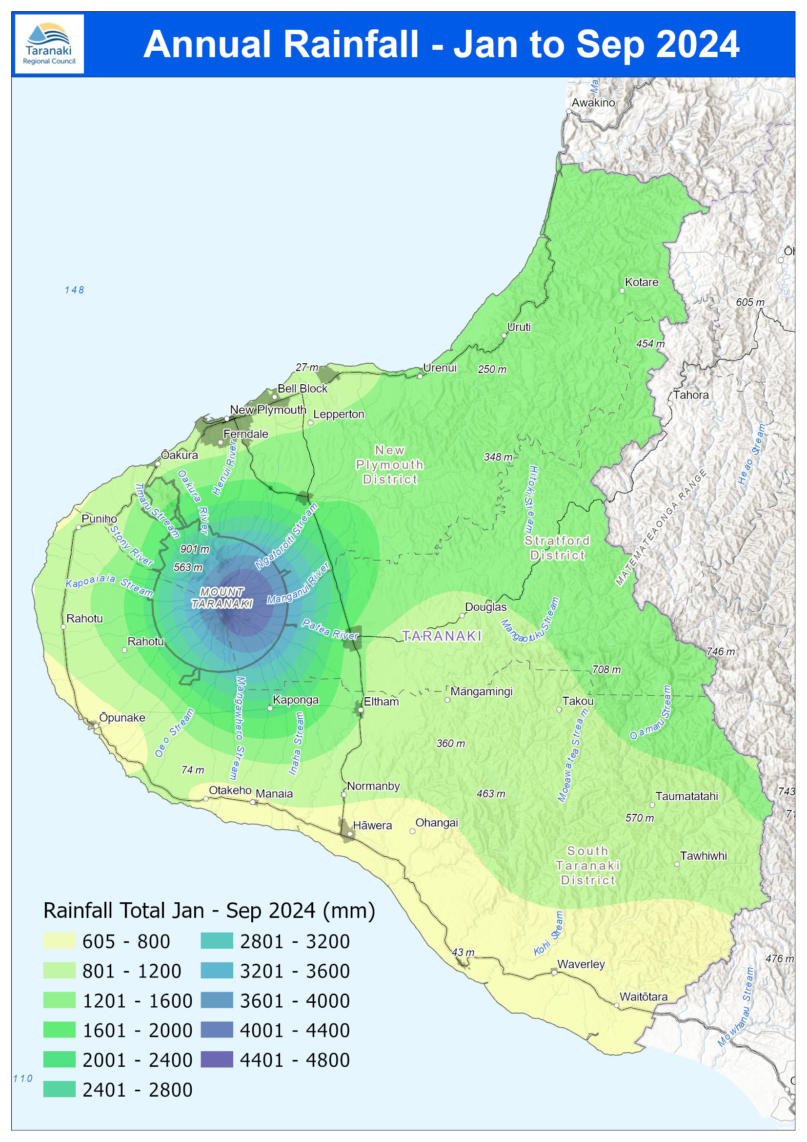
A total of 48 irrigation consents were exercised during the 2023/24 monitoring period, with irrigation
commencing in mid-October and concluding in early April across the region. Rainfall recorded at the
Council’s monitoring locations over the summer irrigation period ranged between 68% and 110% of
historical mean values. Due to the lower than
… page
STRATFORD
WAITARA
Provisional data only
PATEA
NEW PLYMOUTH
OPUNAKE
ELTHAM
MANAIA
HAWERA
EGMONT
NATIONAL
PARK
Total rainfall to date (mm)
KEY
xxx yy%
INGLEWOOD
Pohokura
Saddle
Dawson Falls
Cape Egmont
Stratford
Whareroa
Patea
North Egmont
Inglewood
Motunui
Brooklands
Kaka Rd
Kotare
Rimunui
Glenn Rd
Huinga
99%
89%
93%
94%
73%
101%104%
124%
117%
96%
100%
90%
1460
2122
1968
… page
STRATFORD
WAITARA
Provisional data only
PATEA
NEW PLYMOUTH
OPUNAKE
ELTHAM
MANAIA
HAWERA
EGMONT
NATIONAL
PARK
Total rainfall to date (mm)
KEY
% of average ‘year to date’ rainfall
xxx yy%
INGLEWOOD
Pohokura
Saddle
Dawson Falls
Cape Egmont
Stratford
Whareroa
Patea
North Egmont
Inglewood
Motunui
Brooklands
Kaka Rd
Kotare
Rimunui
Glenn Rd
Huinga
106%
101%
99%
110%
84%
110%112%
130%
123%
… page
STRATFORD
WAITARA
Provisional data only
PATEA
NEW PLYMOUTH
OPUNAKE
ELTHAM
MANAIA
HAWERA
EGMONT
NATIONAL
PARK
Total annual rainfall (mm)
KEY
% of average ‘year to date’ rainfall
xxx yy%
INGLEWOOD
Pohokura
Saddle
Dawson Falls
Cape Egmont
Stratford
Whareroa
Patea
North Egmont
Inglewood
Motunui
Mangorei
Kaka Rd
Kotare
Rimunui
Glenn Rd
Huinga
110%
106%
112%
112%
98%
113%117%
108%
105%
N/A
… page
STRATFORD
WAITARA
Provisional data only
PATEA
NEW PLYMOUTH
OPUNAKE
ELTHAM
MANAIA
HAWERA
EGMONT
NATIONAL
PARK
Total annual rainfall (mm)
KEY
% of average ‘year to date’ rainfall
xxx yy%
INGLEWOOD
Pohokura
Saddle
Dawson Falls
Cape Egmont
Stratford
Whareroa
Patea
North Egmont
Inglewood
Motunui
Brooklands
Kaka Rd
Kotare
Rimunui
Glenn Rd
Huinga
112%
108%
119%
107%
88%
115%110%
121%
124%
page
STRATFORD
WAITARA
Provisional data only
PATEA
NEW PLYMOUTH
OPUNAKE
ELTHAM
MANAIA
HAWERA
EGMONT
NATIONAL
PARK
Total monthly rainfall (mm)
KEY
xxx yy%
INGLEWOOD
Pohokura
Saddle
Dawson Falls
Cape Egmont
Stratford
Whareroa
Patea
North Egmont
Inglewood
Motunui
Brooklands
Kaka Rd
Kotare
Rimunui
Glenn Rd
Huinga
47%
36%
37%
23%
15%
18%11%
28%
15%
21%
22%
30%
33
68
52
Monthly rainfall norms at monitored Taranaki sites.
Council. The topic was discussed following the Ministry for the Environment’s June release of the ‘Climate Change Projections for New Zealand’report. Policy Analyst Denise Young said projected changes in Taranaki include a slight temperature increase of between 0.7 and 3.1 degrees warmer by 2090, along with a rainfall increase of 5-9%. There is also increased risk of erosion, landslides, droughts, severe flooding, invasive pests and weeds, sub-tropical diseases and changed ecosystem composition. “In