Your search for 'iwi map' returned 2245 results.
Appendix 10: Statutory acknowledgements
the Ngati Ruanui, Ngati Tama, Ngaa Rauru Kiitahi, Ngāti Mutunga, Taranaki, Ngāruahine and Te Atiawa deeds of settlement. Information on each statutory acknowledgement, including maps showing the locations of the statutory acknowledgements for these iwi are presented below. Details of the statutory areas for each iwi are included in the relevant regional plan, and more information on each statutory acknowledgement is contained in the relevant iwi deed of settlement
DraftAnnualReport18 web
steps it intends to take to foster the development of Māori capacity to contribute to the decision making processes over the period covered by the Plan. There are eight recognised iwi in the region, Ngaa Rauru Kiitahi, Ngāti Ruanui, Ngāruahine, Taranaki Iwi, Te Atiawa, Ngāti Mutunga, Ngāti Maru and Ngāti Tama. POLICY DEVELOPMENT Opportunities were provided to Māori to be involved in the development of policy and in particular input was sought or opportunities
Taranaki Biodiversity Trust Annual Report - 2015-16
and agrees to commit to them is welcome. We currently have 33 Members and 6 Friends. A number of environmental groups in Taranaki have joined and Taranaki Biodiversity Trust Annual Report 2015/2016 2 page the remainder are in the process of joining. The eight iwi of Taranaki, as Kaitiaki of our region, have been invited to automatically become members. Two workshops have been held for members and the community; Best practice for predator control in
TRC Climate Summary Report August 2025
page Taranaki Regional Council Monthly Rainfall and Environmental Data Report for August 2025 Note: The data presented here is provisional data only and may change as a result of quality control at a later date. 1. Rainfall Map 1: August total rainfall (mm) and percentage of long-term mean (colour key). page Map 1a. Total rainfall 1 January to end August (mm) and percentage of long-term mean (colour key). page Table 1: Rainfall
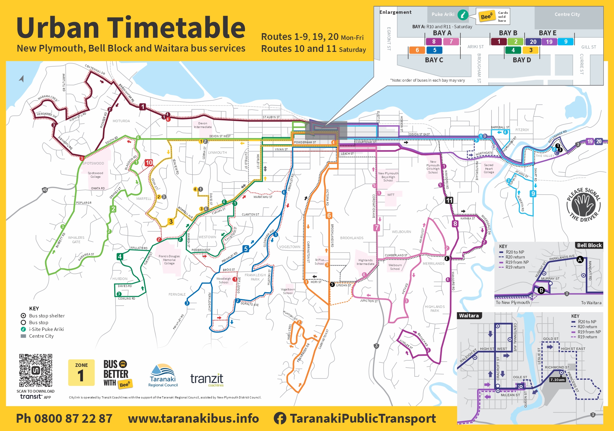
Roadworks to cause Connector disruption
relocate from Moa St to 22 Rata St (outside Farm Source). The Midhirst stop will temporarily relocate from SH3 to the corner of Beaconsfield Rd and Standish St (see map below). The detour is expected to add at least 25 minutes to your journey, so please allow extra time for travel. Northbound travel The northbound Connector service will operate as usual. However delays are possible, so please plan ahead. Stay up to date Any further updates and Connector service alerts will be posted on the Taranaki
Hearing evidence - location map
Property & rates search
Use our online GIS SmartMaps to find valuation rates information for specific properties. Click here to open the interactive property information map. Go to the SmartMaps Property Information map, zoom in and click on your desired property, select 'More Actions' in the pop-up box, then select 'Generate Report'. SmartMaps Property Information Map Contact Us GIS team Phone: 0800 736 222 Email an enquiry
TRC Annual Report 2017-2018 - full document
to take to foster the development of Māori capacity to contribute to the decision making processes over the period covered by the Plan. There are eight recognised iwi in the region, Ngaa Rauru Kiitahi, Ngāti Ruanui, Ngāruahine, Taranaki Iwi, Te Atiawa, Ngāti Mutunga, Ngāti Maru and Ngāti Tama. POLICY DEVELOPMENT Opportunities were provided to Māori to be involved in the development of policy and in particular input was sought or opportunities provided in