seven days. The region's driest January was in 2015. January 2022 hydrology report January 2022 rainfall maps January 2022 rainfall maps [PDF, 736 KB] What you should know: The site maps show data from a selection of the sites we monitor, but not all of them. The distribution maps are based on mathematical modelling and may not accurately represent actual rainfall in some unmonitored areas. Click on each map for larger version. MONITORED SITES RAINFALL DISTRIBUTION Related links Monthly rainfall
Chairperson
N W Walker Committee Deputy Chairperson
M G Davey
M J McDonald
D H McIntyre
E D Van Der Leden
M P Joyce ex officio
D N MacLeod ex officio
Representative
Members Councillors C Young South Taranaki District Council
S Hitchcock New Plymouth District Council
G Boyde Stratford District Council
Mr P Moeahu Iwi Representative
Ms L Tester Iwi Representative Via zoom until 11.30am
Attending Councillor D L Lean
Messrs M J Nield …
Rainfall for April was generally well below the average, ranging from 27% to 72%, with an average of 50% of normal for April. Rainfall was higher around the Maunga and ring plain, and Cape Egmont received 84% of normal rain. Most of the rain fell in two events on 6 and 22 April. Te Maunga recorded between 67% and 79% of normal. Year to date rainfall is sitting between 67% and 213% with an average of 113% of normal. April 2022 hydrology report April 2022 rainfall maps What you should know: The
There’s been a raft of scientific studies – you can find the reports on our website – and we’ve also been running a series of hui with iwi and other water users. So watch this space, and never let anyone tell you that Taranaki’s doing nothing about its waterways! Analysis of stream responses to riparian management (NIWA) [PDF, 2.3 MB] Freshwater & Land Plan review The ecological health of waterways is assessed by studying the small critters and organisms in streams and rivers, and is the primary
JulySubmissions on the Proposed Coastal Plan for Taranaki are likely to be heard late in July, the Policy and Planning Committee was told. The hearing will almost complete the current review of the Plan, and up to 35 submitters are expected to present their cases verbally. The Hearing Committee will consist of two Councillors and an independent commissioner with tikanga Māori expertise. Iwi have been consulted over this appointment, which will be the Council’s first use of such an independent commissioner for
values from
Iwi management plans and statutory
acknowledgements for s32 purposes. The
exercise will also ensure planners have an
understanding of the history of, and
current pressures on, waterbodies in the
region from the tangata whenua
perspective.
Continue to identify and map sites of
significance to Maori for inclusion in the
NRP.
Plan Drafting
Drafting plan provisions for water
allocation
Catchment stocktake
Identify our
Decision Making Framework
ILM Investment Logic Mapping
LOS Levels of Service
LTP Long Term Plan
LTV Long Term View
NOC Network Outcomes Contract
NOF/NOP Network Operating Framework/Networking Operating Plan
NPDC New Plymouth District Council
NZTA New Zealand Transport Agency
ONF One Network Framework
ONRC One Network Roading Classification
PGF Provincial Growth Fund
POE Point of Entry (initiation of a business case)
RAMM Road Assessment and
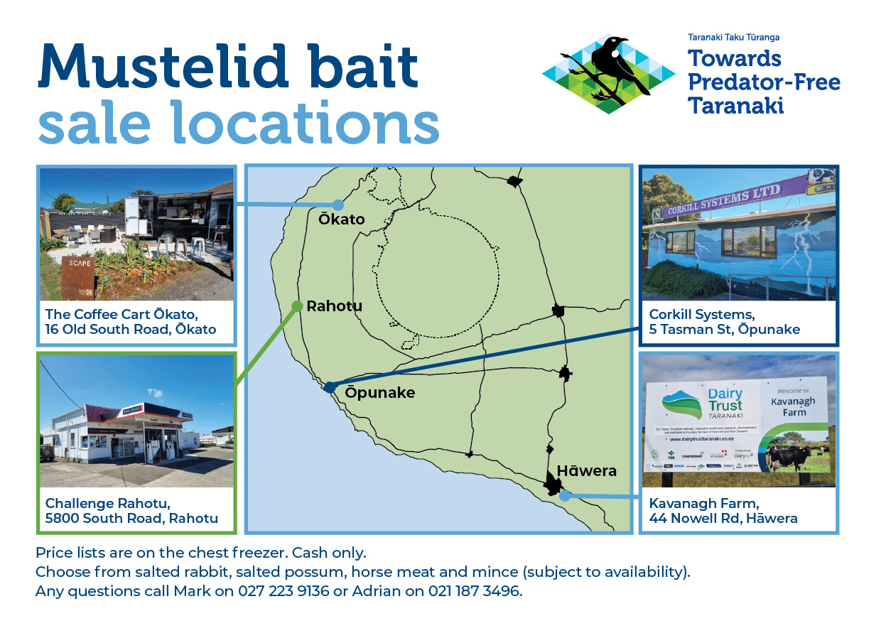
Predator Free Bait Freezer Location Map 2025
_________________________________________________________________________________
_________________________________________________________________________________
Written approval of landowner(s) attached (See section 9) Yes No
3.3 Location of activity (Including: Street/road name, number, and locality)
_________________________________________________________________________________
_________________________________________________________________________________
3.4 Map Co-ordinates at point of discharge (either
_________________________________________________________________________________
_________________________________________________________________________________
3.4 Map Co-ordinates at point of discharge (either Longitude/Latitude or NZTM):
________________________ Longitude ________________________ Latitude OR
________________________ E ________________________ N (NZTM)
3.5 Legal description of property at site of activity (refer to land title or rates notice)