Gazette Notice reference Recreation Reserve: New Zealand Gazette, No 34, 17 March
1983, p 761-762
Record of Title reference 582245 and 582244
District Council / Plans New Plymouth District Council (NPDC)
New Plymouth Operative District Plan (ODP)
New Plymouth Proposed District Plan – Appeals Version (PDP)
Regional Council / Plans Taranaki Regional Council (TRC)
Regional Coastal Plan for Taranaki (CPT)
Address for service during consent
processing
Tonkin & Taylor Ltd
A trailblazing project to eradicate possums from 9,500ha of bush and farmland. Towards Predator-Free Taranaki's Zero Possum project was a New Zealand-first when in 2018 it set out not to simply control possum numbers but to eradicate them from a 4,500 hectare area including 2,300 hectares of the Kaitake Range, 2,000 hectares of Kaitake farmland and Oākura town. In early 2023 the project was expanded by a further 5,000ha, moving the western boundary from the Timaru Stream to the
Find out more about the winner of the award, Malcolm and Lorraine Campbell, and the highly commended, Nigel and Raewyn Chapman – NRGE Farms Ltd and Kieren and Ngaire Faull. This award is proudly sponsored by Fonterra Winner
Malcom and Lorraine Campbell - Araheke Farm
For leadership and excellence in environmental stewardship, sustainable farming and land use practices Malcolm and Lorraine Campbell have been at the forefront of stream restoration and creating habitat for biodiversity for the
Find out which activities have been granted resource consents by the Council. All resource consents issued by the Council are displayed on the Resource Consent Map that's part of our online GIS SmartMaps. Click here to open the interactive resource consents map When the map is open, zoom into your area of interest. Resource consents are indicated by small coloured shapes - to see what each of these means, select 'Legend' in the header bar above the map. Click on your consent of interest, and a
relevant regional plan(s)
Assessment of the activity against any relevant National Policy Statement(s) and National
Environmental Standards
Provided an assessment of your proposed activity against the matters sent out in Part 2 of the RMA
Site plan, engineering plans and calculations
Consent duration sought
Provided a site sediment and erosion control plan if required
Applied for any district council consents that are also required for your proposal
Signed
Education category winners in the 2020 Taranaki Regional Council Environmental Awards.
under clause 14 of the First
Schedule to the Act
BETWEEN Petroleum Exploration and Production
Association of New Zealand
Appellant
AND Taranaki Regional Council
Respondent
NOTICE OF APPEAL
page
2
TO: The Registrar
Environment Court
AUCKLAND
1. The Petroleum Exploration and Production Association of New
Zealand (PEPANZ) appeals part of a decision of Taranaki
Regional Council
The rohe of Taranaki Iwi extends along the coastal and mountain area between Ōuri and the Rāwa o Turi stream in the south and Ōnukutaipari in the north. Taranaki Iwi interests also extend inland to Te Whakangerengere on the northeastern flank of the mountain, up the Waipuku stream to Te Tahuna o Tūtawa (Warwicks Castle), over to Panitahi (Fanthoms Peak) and down to Mangoraukawa (Lake Dive) and the source of the Ōuri stream. It then follows the Ōuri stream water course towards the coast, with a
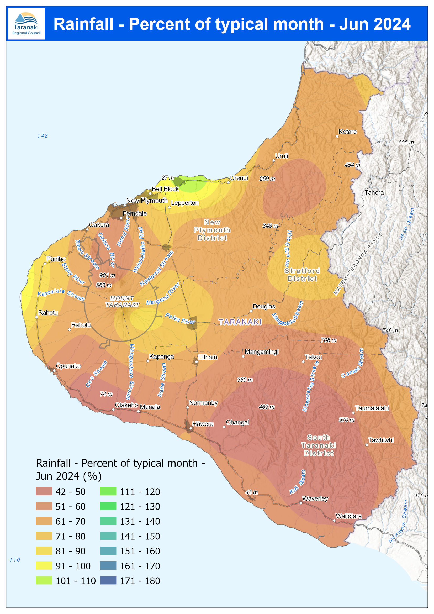
October was a month of contrasts for rainfall in Taranaki, ranging from 65% of the average for the month at Waitotara at Hawken Rd to 164% at Mangati at SH3. The average across the region was 101.1% of the long-term average although there was less rain on the Maunga where rainfall was only around 60% at North Egmont and Kahui Hut. Year to date rainfall is sitting between 110% (Kotare at OSullivans) and 163% (Kapoaiaia at Lighthouse) with an average of 126.8% of normal. Mean river flows for