Committee - Opening Karakia
4
page
Date 15 March 2022
Subject: Confirmation of Minutes - 1 February 2022
Approved by: A J Matthews, Director - Environment Quality
S J Ruru, Chief Executive
Document: 3007526
Recommendations
That the Consents and Regulatory Committee of the Taranaki Regional Council:
a) takes as read and confirms the minutes and resolutions of the Consents and Regulatory
Committee meeting of the Taranaki Regional Council held at the
bunding. This material is then
covered with top soil or A1 grade material. The discharge of B1 grade compost on site will
be compliant with Rule 29 of the Taranaki Regional Council Regional Freshwater Plan.
Before compost can be released for use on site it must pass/meet the following
specifications as shown in table 1 below.
Further testing of compost will be required for release of product off site. This testing will be
against the ‘Guidelines for Safe Application of Biosolids to Land in
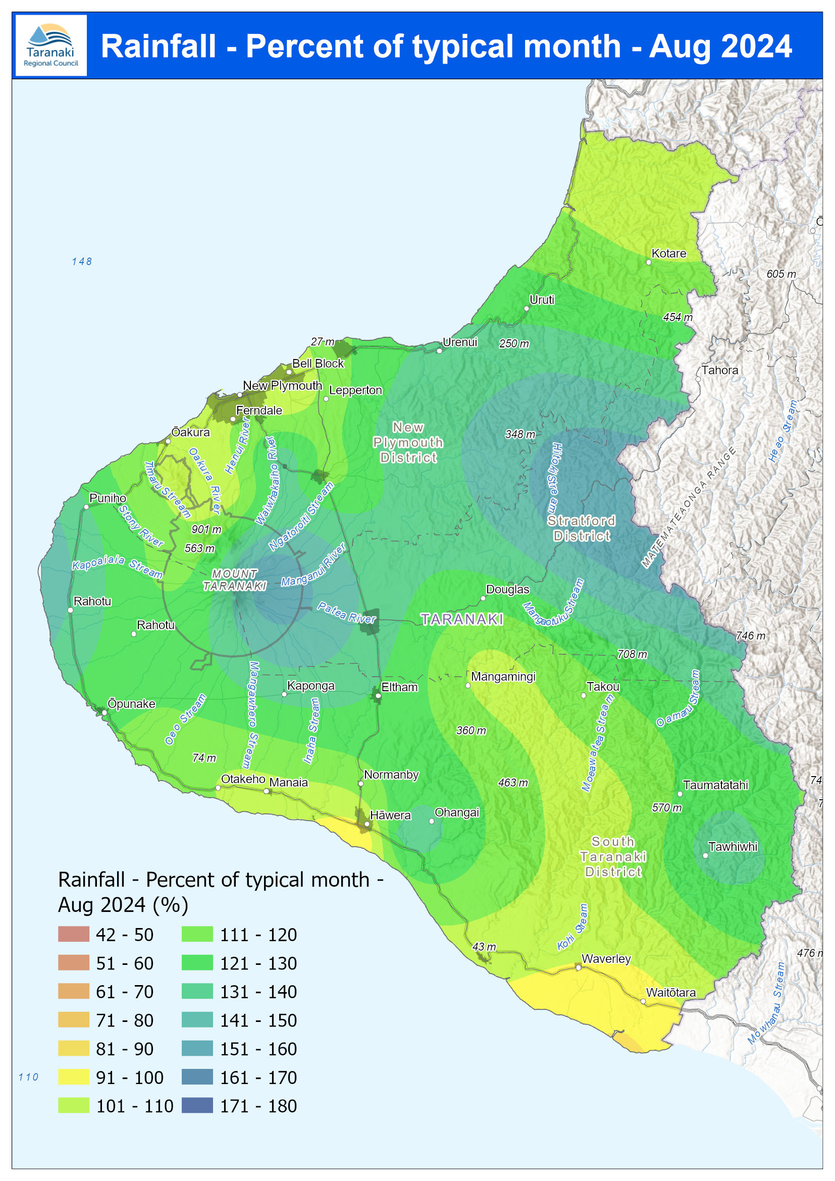
low flows were 243.5%, and high flows 114.3%, of typical values while Mean river (non-mountain) water temperatures were 14.4ºC, an average of +0.3ºC different to long-term April values. The average air temperature for the region (excluding Te Maunga sites) was 15.2ºC, which is +0.6ºC relative to normal. April 2023 hydrology report For a more detailed analysis of the rainfall at the North Egmont Visitors Centre, click here. April 2023 rainfall maps What you should know: The site maps show data from
party by your
proposal, including neighbours and tangata whenua. We are happy to provide you with the correct contact
information and anything else you might require with regards to communications and engagement.
If you have any questions relating to completion of this application form, please contact the Consents
Department, Taranaki Regional Council on telephone (06)765-7127 or email consents@trc.govt.nz.
Marine and Coastal Area (Takutai Moana) Act 2011
Before lodging
anything else you might require with regards to communications and
engagement.
If you have any questions relating to completion of this application form, please contact the Consents
Department, Taranaki Regional Council on telephone (06)765-7127 or email consents@trc.govt.nz.
This form must be completed and lodged with accompanying documentation prepared for the purpose of
lodging resource consent applications under the Resource Management (National Environmental
Standards for
tangata whenua. We are happy to provide you with the correct contact
information and anything else you might require with regards to communications and engagement.
If you have any questions relating to completion of this application form, please contact the Consents
Department, Taranaki Regional Council on telephone (06)765-7127 or email consents@trc.govt.nz.
Marine and Coastal Area (Takutai Moana) Act 2011
Before lodging this application you must seek comment from applicants for
Read our latest Annual Report and Quarterly Operational Reports. Pre-Election Report The Taranaki Regional Council’s Pre-Election Report for the October 2019 local authority is intended to inform the regional community and to promote public discussion about any financial issues facing the Council. As is required by law, this Pre-Election Report is prepared by the Council’s Chief Executive rather than elected Council members. Pre-Election Report 2019 (718 KB pdf) (single document only)
page
1
Future directions for the management of oil
and gas operations in the Taranaki region
Review of the Regional Freshwater Plan for Taranaki
Taranaki Regional Council
Private Bag 713
Stratford 4352
November 2013
Document: 1238455
page
2
Disclaimer
This working paper has been prepared by the Taranaki Regional