The Council's navigation & safety bylaws for Port Taranaki and its approaches aim to make this area safe for all users, commercial and recreational. Harbour areas
Recreational facilities
Speed restrictions The harbour limits for Port Taranaki and its approaches are defined by the sea area within a 2.5 nautical mile radius from Moturoa trig. Port Taranaki and its approaches (click on map for large version). The Port and its approaches have a wide range of users, from large merchant ships and
making unicorns out of metal! Nathan’s the one with the ideas and we work well as a team. He pours out creative stuff and I play off that.” Their work carries a nostalgic significance, with recycled metal playing a key role. The couple love watching people discover objects in each piece that spark memories of the past. “People spot familiar objects, like a green-painted handle or an old-fashioned hammer, that remind them of a grandparent’s kitchen or workshop. Every piece tells a story, but it’s
Our young people are among the biggest champions of the predator free vision. Schools and students are leading residents’ efforts to restore native wildlife and plants, for the next generation. Taranaki schools are ambassadors of Towards Predator-Free Taranaki, many distributing traps to households to raise funds for environmental school projects. Students are helping expand urban trapping by checking traps in public parks and reserves. They are making trap boxes and helping monitor
Description
1.0 February 2018 As adopted by Taranaki Regional Council at the
Ordinary Meeting on 20 February 2018
1.1 March 2021 Plan change for Inclusion of mustelids
1.2
page
page
The Taranaki Regional Council under Part V of the Biosecurity Act 1993 approved this document entitled
Regional Pest Management Plan for Taranaki at its Ordinary Meeting on 20 February 2018 and it became operative
on 20 February 2018.
page
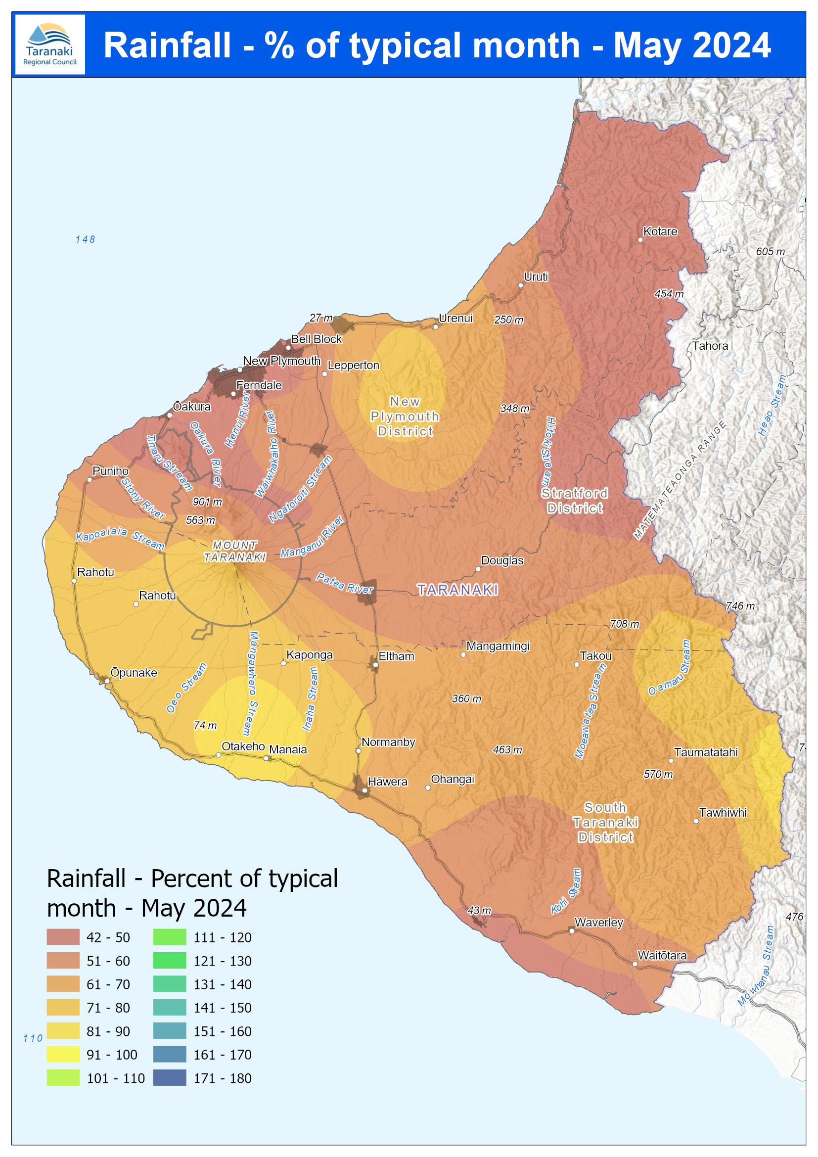
Taranaki Regional Council Monthly Rainfall and Environmental
Data Report for June 2025
Note: The data presented here are provisional data only and may change as a result of quality control at a later date.
1. Rainfall
Map 1: June total rainfall (mm) and percentage of long-term mean (colour key).
page
Map 1a. Total rainfall 1 January to end June (mm) and percentage of long-term mean (colour key).
page
Table 1: Rainfall June and year
holiday shopping, or just exploring the region, let us take care of the driving while you enjoy the perks: 🎁 Save money for holiday treats
🚍 Skip parking hassles and traffic stress
🌍 Make a positive impact on the environment All routes are included, including Citylink (New Plymouth, Bell Block and Waitara), Connector (Hāwera to New Plymouth), and Southlink (Ōpunake to New Plymouth) services. 📅 Plan your trip today and make the most of Free Fridays this December. Check out the routes below: Follow
for liquid petroleum gas.
This report for the period July 2023 to June 2024 describes the monitoring programme implemented by
Taranaki Regional Council (the Council) to assess the Company’s environmental and consent compliance
performance during the period under review. The report also details the results of the monitoring
undertaken and assesses the environmental effects of the Company’s activities.
During the monitoring period, Port Taranaki demonstrated a level that required