page
Date: 10 June 2025
Venue: Taranaki Regional Council Boardroom, 47 Cloten Road, Stratford
Document: TRCID-1492626864-827
Present: S W Hughes Chair
B J Bigham
M G Davey
D M Cram zoom
C L Littlewood zoom
C S Williamson ex officio
N W Walker ex officio
R Buttimore Iwi Representative
D Luke Iwi Representative
Ā White Iwi Representative
Attending: S J Ruru Chief Executive
A J Matthews Director - Environment Quality
D
Resource Management
Act 1991 and the Local Government Official Information and Meetings Act 1987.
Iwi considerations
19. This memorandum and the associated recommendations are consistent with the
Council’s policy for the development of Māori capacity to contribute to decision-making
processes (schedule 10 of the Local Government Act 2002) as outlined in the adopted long-
term plan and/or annual plan.
Community considerations
20. This memorandum and the associated recommendations
appointments of representatives to the Council’s Operations and
Regulatory Committee and Policy and Planning Committee received from
Taranaki Federated Farmers
f) noted two further Iwi Representatives will be appointed to the Council's
Operations and Regulatory Committee
g) determined that this decision be recognised as not significant in terms of section
76 of the Local Government Act 2002
h) determined that it has complied with the decision-making provisions of the Local
Government Act
protected wetlands in the Taranaki region (182 KB pdf) Appendix 2B: Values of regional significant unprotected wetlands in the Taranaki region (169 KB pdf) Appendix 3: Wetlands with nationally or regionally rare, threatened or uncommon flora or fauna (36 KB pdf) Appendix 4: Catchment maps (707 KB pdf) Appendix 5: Surface water quality guidelines (106 KB pdf) Appendix 6: Good agrichemical spray management practices (106 KB pdf) Appendix 7: Good management practices for discharge of agricultural effluent
protected wetlands in the Taranaki region (182 KB pdf) Appendix 2B: Values of regional significant unprotected wetlands in the Taranaki region (169 KB pdf) Appendix 3: Wetlands with nationally or regionally rare, threatened or uncommon flora or fauna (36 KB pdf) Appendix 4: Catchment maps (707 KB pdf) Appendix 5: Surface water quality guidelines (106 KB pdf) Appendix 6: Good agrichemical spray management practices (106 KB pdf) Appendix 7: Good management practices for discharge of agricultural effluent
Confirmation of Policy and Planning Minutes - 14 March 2023
4
page
Date 14 March 2023
Venue: Taranaki Regional Council Boardroom, 47 Cloten Road, Stratford
Document: 3154919
Present C S Williamson Committee Chairperson
D M Cram
D H McIntyre
S W Hughes
B J Bigham
C L Littlewood ex officio
N W Walker ex officio
E Bailey Iwi Representative
P Moeahu Iwi Representative
M Ritai Iwi Representative
G Boyde Stratford
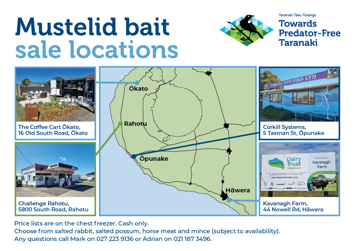
Predator Free Bait Freezer Location Map 2025
Regulatory Committee - Confirmation of Operations and Regulatory Minutes - 29 April 2025
5
page
Date: 29 April 2025
Venue: Taranaki Regional Council Boardroom, 47 Cloten Road, Stratford
Document: TRCID-1492626864-638
Present: S W Hughes Chair
M J Cloke
D M Cram
B J Bigham
D M McIntyre
D L Lean (zoom)
C L Littlewood (zoom)
C S Williamson ex officio
N W Walker ex officio
R Buttimore Iwi Representative
D Luke Iwi Representative
Ā
Operators Guide to writing a Freshwater Farm Plan Te Uru Kahika (7.8 MB pdf) A farm operators guide to FWFP mapping Te Uru Kahika (2.3 MB pdf)